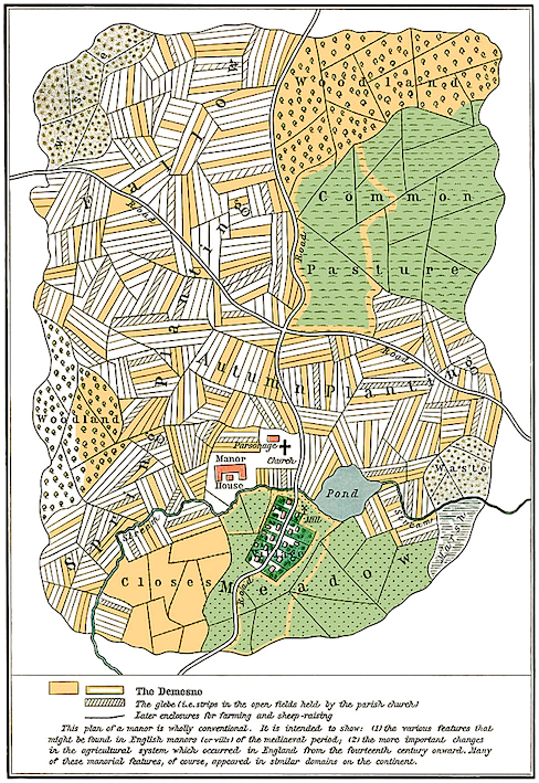
Jay Doubleyou: Schools are taking this seriously
For example, a Medieval manor:
17_medimanor.jpg (488×709)
And these can be supplemented by aerial photography - with some more Medieval stuff:
Jay Doubleyou: Tintagel
This can provoke a few questions - such as 'What exactly are we looking at?'
Jay Doubleyou: A field trip
Here we are in Roman Devon:
Jay Doubleyou: Something from the air…
And Roman Exeter (pages 43 and 59):
rammuseum.org.uk/web/data/page_data/Romans-in-Devon-and-Iron-Age-Background-Notes.pdf
Here are some great maps showing how the Industrial Revolution affected the British landscape - right out in the middle of the countryside:
Power in the Landscape - Home
Power in the Landscape - Water powered mills in the Upper Calder Valley
... especially Hebden Bridge, 1907 Ordnance Survey Map:
Design ideas final - chopup
Looking at any map of a town or city today, what can you say about:
> the history of the streets (their names, their shape),
> the layout of the districts (which were built first and what were they for?),
> the bits of natural geography (underground streams, old trees)?
And for the countryside, here is a useful list - but only if you're in Britain!
The scope of landscape history ranges from specific individual features to areas covering hundreds of square miles.[6] Topics studied by landscape historians include:
- the form (morphology) of settlements - for example whether they are dispersed or nucleated;
- the status of settlements - for example Anglo-Saxon multiple estates;
- deserted medieval villages which provide evidence of earlier village forms;
- field systems which can be used to date landscape features as well as illuminating earlier landscapes;
- field boundaries or boundaries of larger units such as parishes or counties;
- place-names which have been used to illustrate landscape features, particularly Anglo-Saxon place-names.
Landscape history - Wikipedia, the free encyclopedia
.
.
.
No comments:
Post a Comment